
Geneva Lake Shore Path Guide
What Is the Geneva Lake Shore Path?
- Total path distance: 21 miles (some measurements stretch toward 21.4 to 21.9 miles depending on route interpretation)
- Elevation gain: approximately 446 feet
- Estimated full-loop time: 7 to 10 hours
- Trail type: moderate
- Surface: varies constantly, from packed dirt and grass to limestone walkways, narrow footbridges, and uneven terrain near private grounds
The 10 Official Access Points
You can enter and exit the Shore Path at 10 official public access points, labeled A through J on the official Williams Bay Recreation Department map. Here’s the full rundown:
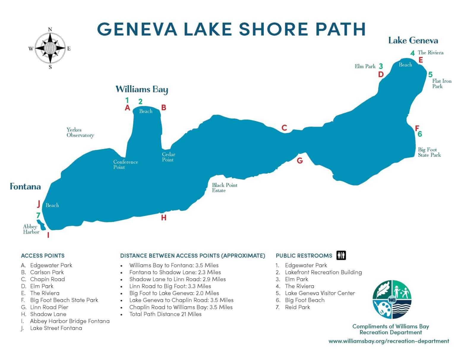
| Access Point | Location | Notes |
| A. Edgewater Park | Williams Bay | Public restroom available |
| B. Carlson Park | Williams Bay | Good mid-lake starting point |
| C. Chapin Road | Mid-lake north shore | Quieter entry |
| D. Elm Park | Lake Geneva area | Public restroom available |
| E. The Riviera | Downtown Lake Geneva | Public restroom nearby |
| F. Big Foot Beach State Park | East end | Restroom + parking (state park sticker required) |
| G. Linn Road Pier | Linn Township | Quieter access; limited parking |
| H. Shadow Lane | South shore / west end | Great starting point for the south shore segment |
| I. Abbey Harbor Bridge | Fontana | West-end harbor access |
| J. Lake Street Fontana | Fontana | Beach and harbor; good parking |
Practical Notes on Parking
- Downtown Lake Geneva (Library Park): Easiest access for first-timers. Street parking and public lots nearby. Can get crowded midday in summer.
- Big Foot Beach State Park: Good option for longer, quieter walks. Requires a Wisconsin state park sticker. More space, easier summer parking.
- Williams Bay (Edgewater Park/public beach): Good mid-lake entry. Summer parking is limited, especially on weekends. Go early.
- Fontana (Lake Street area): Strong west-end access with reasonable parking near the harbor.
- Linn Township (Linn Road Pier): Lower traffic. Limited parking, but a quieter entry for people who want fewer people.
Local tip for summer Saturdays: arrive before 9am or after 3pm. Midday parking around Williams Bay and downtown Lake Geneva turns into a full-contact sport.
Distances Between Access Points
Approximate distances between the main access points, as documented on the official Williams Bay Recreation Department Shore Path map:
| Segment | Distance (Approximate) |
| Williams Bay to Fontana | 3.5 miles |
| Fontana to Shadow Lane | 2.3 miles |
| Shadow Lane to Linn Road | 2.9 miles |
| Linn Road to Big Foot Beach | 3.3 miles |
| Big Foot Beach to Lake Geneva | 2.0 miles |
| Lake Geneva to Chaplin Road | 3.5 miles |
| Chaplin Road to Williams Bay | 3.5 miles |
| TOTAL PATH DISTANCE | 21 miles |
A note on total mileage: different sources give different numbers. The Williams Bay Recreation Department map lists the total at 21 miles. Other trail guides measure between 21.4 and 21.9 miles. Some accounts stretch toward 26 miles depending on how the route winds and where measurements begin and end. The cleanest answer is the path is approximately 21 miles.
Public Restrooms Along the Path
There are 7 public restroom locations identified on the official Shore Path map, all located at major access points:
- 1. Edgewater Park (Williams Bay)
- 2. Lakefront Recreation Building (Williams Bay)
- 3. Elm Park (Lake Geneva area)
- 4. The Riviera (Downtown Lake Geneva)
- 5. Lake Geneva Visitor Center
- 6. Big Foot Beach State Park
- 7. Reid Park
Restrooms at public access points may be locked depending on the time of day or the time of year. If that happens, most nearby restaurants will let walkers use their facilities. The Shore Path community runs on a certain understanding.
AT A GLANCE
Total Distance: 21 miles | Difficulty: Moderate | Elevation: ~446 ft | Full Loop: 7-10 hours | Dogs: Yes (leashed) | Bikes: No | Strollers: No | Open: Year-Round
The History of the Shore Path (It Goes Way Back)
Before this path had a name, it had footprints. Thousands of years of them.
As early as 2,500 BC, Native American tribes walked this same shoreline route. The Potawatomi people, who lived along Geneva Lake until 1836, used the path to travel between their villages in areas now known as Fontana, Williams Bay, and Lake Geneva. The lake they walked beside was known as Kishwauketoe, meaning “clear water.”
Worth pausing on that for a second. The path you’re walking today? People have been walking it for millennia. That weight is real.
The Lake’s Name and Why It Still Confuses People
Quick note because this comes up constantly: the lake is officially Geneva Lake, not Lake Geneva. Lake Geneva is the name of the city at the eastern end of the lake. Over generations, the names blended in everyday conversation and now both get used interchangeably. Locals will smile when you mix it up. Or correct you. Depends on the local.
The Chicago Connection
After the Great Chicago Fire in 1871, wealthy Chicago Buyers began looking for places to put down summer roots. Geneva Lake became one of the most desirable destinations. Rail lines made it reachable. The landscape made it beautiful. And that ancient shoreline path made it practical.
Historic Estates and Private Grounds
Many of the lakefront homes date back generations. Some have been rebuilt or updated, but the scale and placement reflect the original era of Chicago family retreats. You’re walking through maintained private property: flower beds, stonework, manicured lawns. All of it visible from the path. The contrast between pristine landscaping and the natural edge of the lake is one of those things you can’t quite describe until you’ve seen it.
Snake Road: The Gilded Age Cottages of Geneva Lake
One of the most storied stretches of the entire Shore Path runs along the north shore through what locals have long called the Snake Road area. This is where Geneva Lake’s Gilded Age history comes fully into view.
- Wrigley Properties (associated with the Wrigley family of Chicago chewing gum fame)
- Green Gables
- Hillcroft
- Flowerside Inn
- Wadsworth Hall
Natural Shoreline Sections
Between the estates, the lake shows its quieter side. Clear water, natural rocky edges, long uninterrupted views. The Shore Path’s terrain shifts constantly, which is part of what makes it feel more like an experience than a workout.
Black Point Estate
One of the most notable historic landmarks along the path is Black Point Estate on the south shore. It’s a recognizable anchor point for walkers doing the middle sections of the lake and a genuinely beautiful stretch of shoreline.
Yerkes Observatory
Located near Williams Bay, Yerkes Observatory is one of the most recognizable landmarks on the western end of the lake. You can see the iconic domed building from the Shore Path as you walk through the Williams Bay section. Worth noting: Yerkes is visible from the path, but it is not accessible from the path. If you want to visit, plan a separate stop.
The Best Shore Path Segments
Most people do the path in sections. Not all at once.
1. Downtown Lake Geneva to Black Point | ~6 miles one way
This is the stretch people talk about most, and the mileage commitment is real: about 6 miles one way from Library Park out toward Black Point. Give yourself a solid half-day for this one.
Start in downtown with coffee if you’re smart about it. Within minutes you’re on the water. Then the crowds thin, the homes get larger, the path narrows. You pass through some of the quietest and most photogenic stretches on the east and south shore. And if you time it right, you’ll reach Black Point Estate, one of the most recognizable historic landmarks on the entire lake.
Best for: first-timers who want the full Lake Geneva Shore Path experience, history lovers, strong walkers with half a day to spare.
2. Williams Bay to Fontana | ~3.5 miles
One of the most underrated stretches on the whole path. You start near the water in Williams Bay and settle into a rhythm quickly. Long open views across the lake. Less congestion than the downtown sections. And when you finish in Fontana, Gordy’s and Chuck’s are right there with cold drinks and great burgers. Walking into lunch is a legitimate life strategy.
Best for: balanced walk with good scenery plus a food payoff, slightly quieter pace.
3. Big Foot Beach to Lake Geneva | ~2.0 miles
Shorter, but a solid option. Easy access from the state park, and the stretch toward downtown Lake Geneva gives you some of the most photogenic waterfront views on the lake. Great if you don’t want a long commitment and still want the Shore Path feel.
Best for: shorter walks, Weekenders , state park visitors.
4. Fontana Harbor Area | ~1 to 2 miles
Sometimes you just want a walk that feels like the lake without turning it into a production. Start near the harbor, move into quieter shoreline sections, enjoy the water. Good footing. Minimal planning. High reward.
Best for: easy scenic walk, Weekenders , quick afternoon outing.
5. Fontana to Shadow Lane to Linn Road Pier | 2.3 miles + 2.9 miles
Starting from Fontana and walking east through Shadow Lane to Linn Road Pier covers about 5.2 miles of some of the most beautiful and historically layered shoreline on Geneva Lake. Shadow Lane sits on the south shore west end, and from there the path moves through increasingly quiet, more nature-forward terrain as you approach Linn Road.
The Shore Path in Every Season
The path is open year-round. That’s not something most lakefront destinations can offer, and it changes everything about how you experience the lake.
Spring
The path comes back to life. Grass greens up. Trees fill in. The smell of cut grass in the air on a warm May morning is one of those sensory memories people talk about years later. Lighter crowds, crisper air, the whole lake feeling like it just exhaled.
Summer
Peak season. More walkers, boats on the water, fully occupied lakefront homes. This is when the path feels most alive. It’s also when you most want to go early or late to avoid the midday heat. Extreme summer heat and humidity can make a long stretch genuinely unpleasant.
Fall
Honestly one of the best times to walk. Cooler temps, changing leaves, fewer people. The water takes on a different quality of light. If fall weekend plans are being made and someone asks what to do in Lake Geneva… this is the answer.
Winter
A completely different path. Quiet, snow-covered sections, that specific silence that only comes when a lake town empties out for the cold. Not for everyone, but for the right person, it’s extraordinary.
Know Before You Go
The Path Is Public. The Property Is Not.
The Shore Path exists because private property owners have maintained public access through their land for generations. That tradition only continues if walkers stay on the path and respect what’s on either side of it. No walking onto lawns, no stepping onto piers or docks, no shortcuts through private grounds.
Wear Real Shoes
The terrain changes constantly. You’ll move from packed dirt to limestone to wooden footbridges to grass. Some sections get steep and slippery. Wear shoes with solid arch support and good tread. This is not a flip-flop situation.
No Bikes. No Strollers.
The path is not wide enough, flat enough, or surfaced for wheels of any kind. For people with mobility limitations, the Lake Geneva Public Library offers a smoother paved section for about a half mile in either direction.
Dogs Are Welcome (With Conditions)
Dogs are allowed on the Shore Path but must be kept on a leash and cleaned up after. Non-negotiable. This is private property, remember.
Cell Service Can Be Spotty
Some sections have limited cell coverage. Download offline maps before you go if you’re not familiar with the route.
What to Bring
- Water (especially for anything over 2 miles)
- Sunscreen
- Bug spray in late spring and early summer
- Comfortable, supportive footwear with good traction
- Leash if you’re bringing a dog
Restaurants Near the Shore Path
Williams Bay
- Pier 290 (on the lake, local and organic menu, 1 block off the path)
- Harpoon Willies (just off the path, lakeside casual)
- Green Grocer
- Bay Cooks
Fontana
- Gordy’s Boat House (on the lake, great burgers)
- Chuck’s (on the lake, reliable classics)
- Surf Shack
Linn Township
- Oak & Oar Patio
- Boat House Bar & Grill
Lake Geneva
- Oakfire
- Nick’s
- Barrique Bistro & Wine Bar
- Baker House
- Gotham – New York Bagels & Eats
Ready to Explore More of Lake Geneva?
The Shore Path is a great introduction to what makes this area different. If it pulls you in the way it tends to pull people in, here’s where to go next:
- Check the Events Calendar for what’s happening this week around the lake
- Browse Community Guides for Williams Bay, Fontana, Lake Geneva, and Linn Township
- Explore the full Things To Do guide for outdoor activities, dining, and seasonal attractions
- Find restaurants along the lake for post-walk planning
If you find yourself wondering what it would look like to spend more time here…
Explore Lakefront and Nearby Properties
Frequently Asked Questions About the Geneva Lake Shore Path
What is the Geneva Lake Shore Path?
The Geneva Lake Shore Path is a public walking trail that circles the entire shoreline of Geneva Lake in Wisconsin. It passes through private lakefront properties while maintaining continuous public access, connecting the communities of Williams Bay, Fontana, Linn Township, and Lake Geneva.
How long is the Geneva Lake Shore Path?
The path is approximately 21 miles total, though measurements vary between 21 and 21.9 miles depending on the source and how the route is traced. The Williams Bay Recreation Department map lists the total distance at 21 miles.
How long does it take to walk the full Geneva Lake Shore Path?
The full loop typically takes 7 to 10 hours at a steady walking pace with minimal stops. Most visitors walk individual segments of 1 to 4 miles rather than the entire loop.
Where do you start the Geneva Lake Shore Path?
The most popular starting points are Library Park in downtown Lake Geneva, the Williams Bay public beach and boat launch (Access Point A: Edgewater Park), Fontana Harbor (Access Points I and J), and Big Foot Beach State Park (Access Point F).
Is the Geneva Lake Shore Path public?
Yes, the path is public. It runs through private property, so walkers must stay on the designated path and respect private lawns, piers, docks, and grounds on either side.
Can you bike the Geneva Lake Shore Path?
No. Bikes, strollers, and wheeled equipment are not permitted on the Shore Path due to terrain and access limitations. The path is for walking only.
Where are the restrooms on the Geneva Lake Shore Path?
There are 7 public restroom locations: Edgewater Park, the Lakefront Recreation Building, Elm Park, The Riviera, the Lake Geneva Visitor Center, Big Foot Beach State Park, and Reid Park. All are located at public access points and may be locked depending on the time of day or season.
Are dogs allowed on the Geneva Lake Shore Path?
Yes, dogs are allowed but must be on a leash and owners must clean up after them.
What is the best section of the Geneva Lake Shore Path for first-timers?
The stretch from Library Park in downtown Lake Geneva toward Black Point is the most recommended first-time walk, covering approximately 6 miles one way. It offers easy parking, direct lake access, and a mix of active downtown energy and quieter historic shoreline.
What is the easiest part of the Shore Path?
The area around the Lake Geneva Public Library offers the smoothest, most accessible terrain. Walking about a half mile east or west from Library Park gives the most even footing on the entire route.
Can you see Yerkes Observatory from the Shore Path?
Yes. Yerkes Observatory is visible from the Shore Path as you walk through the Williams Bay section on the western end of the lake. However, Yerkes is not accessible from the path. To visit the observatory, plan a separate stop.
What historic estates are on the Geneva Lake Shore Path?
The Shore Path passes numerous Gilded Age estates, particularly along the north shore Snake Road section. Notable estate names include Wrigley Properties, Green Gables, Hillcroft, Flowerside Inn, and Wadsworth Hall, built by prominent Chicago industrialist Weekenders in the late 19th and early 20th centuries